Perú has a long list of enigmatic attractions, but without a doubt this is one of the most mysterious. These are large figures (the largest is 300 meters) drawn on the ground with geometric shapes, animals and a humanoid, using a technique that fills the lines with stones to create a color contrast that is later covered by sand, and thus a long-lasting effect is obtained.
What are Nazca Lines? Who could make them? So that? For whom? Next, we will tell you all about the Nazca Lines in Perú.
General information:
Schedule:
- Viewpoint: 8am – 5:30 pm
- Overflight*: 6am – 5pm
* Reference schedule
Price:
- Depends on the operator
- Viewpoint: 1 USD
Indispensable:
- Camera, sunscreen, warm weather clothing, cash.
Height:
- 520 ms. n. m. (City of Nasca)
Weather:
- Min. 23 ° C / Max. 32 ° C
What are Nazca Lines?
The Nazca Lines are a series of roads traced on the earth’s surface that occupy a vast area located in the Nazca desert, located in the department of Ica in Perú.
These are geoglyphs (drawings drawn on the ground) in the shape of geometric, anthropomorphic, zoomorphic and phytomorphic figures.
They were traced by removing materials from the earth’s surface, pebbles of a reddish color caused by oxidation, revealing a paler earth, which is what draws the forms that can be seen from above. The work has been preserved practically intact throughout the centuries thanks to the fact that it hardly rains in the area, which has favored its preservation.
Traced on the ground between 500 BC. and 500 AD, the lines pose one of the greatest enigmas in archeology due to their number, nature, size, and continuity.
Nazca Lines Location
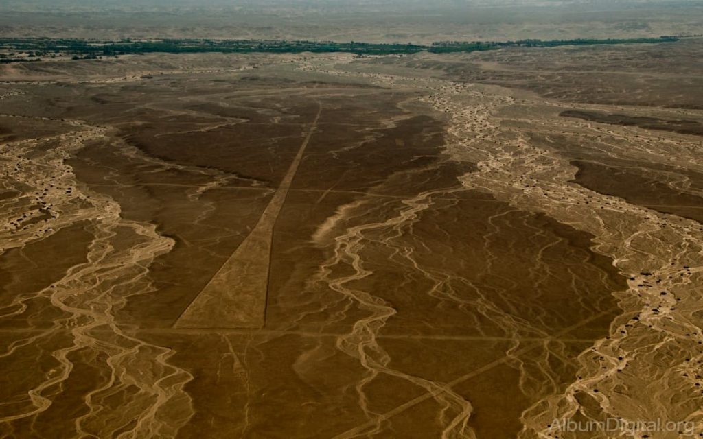
Located in the arid coastal plain of Perú, about 400 kilometers south of Lima, the Nazca and Pampas de Jumana geoglyphs cover about 450 km2.
The exact location of the Nazca Lines geoglyphs is the Pampas de Jumaná, Ica region, in Perú, South America. Nazca is a town located 500 km south of Lima at an altitude of 600 m, the name «Nazca» comes from the ancient and enigmatic pre-Inca culture.
If you are planning a travel itinerary to Perú for 15 Days, do not forget to include a visit to this wonder of Peru
Meaning of Nazca Lines
The Nazca Lines geoglyphs represent living creatures, stylized plants, fantastic beings, and geometric figures several kilometers long.
In 2019, a Japanese scientific team has managed to make an evaluation of the Nazca Lines geoglyphs to explain the meaning of 16 of them. According to Masaki Eda, one of the co-authors of the study published in the Journal of Archaeological Science, the 16 geoglyphs cataloged belong to birds, although they all have a common peculiarity: none of them is indigenous to Peru.
Purpose of Nazca Lines
Paul Kosok and Maria Reiche considered that the purpose of the Nazca Lines in Perú, more than 550 years old, was to represent a solar and lunar calendar, used by ancient Peruvian astronomers.
However, its purpose is unknown so far.
10 Facts about Nazca Lines
Below, we’ll share some facts about Nazca Lines you probably didn’t know about these intriguing geoglyphs that attract thousands of visitors each year.
1. Curious way of observing them
There are three ways to see a large part of the Nasca lines: from the surrounding hills, in some of the observation towers or flying in a small plane.
2. Multiple strokes
There are in total about 800 designs. Among the best known are the figures of animals that add up to a total of 70 and that can measure up to 270 meters in length. Some of the most famous are the hummingbird, the condor, the pelican, the spider, the monkey, the condor and the so-called «Astronaut» (an anthropomorphic figure that would actually represent a fisherman).
3. Thousands of years old
According to studies, the finding of wooden stakes in some points reveals that the lines were designed between the years 500 a. C. and 500 d. C.
4. American discoverer
It was Paul Kosok who discovered them in 1927. The American anthropologist hypothesized that the figures represented a great astronomical calendar.
5. Form of elaboration
To draw the thinnest lines, the inhabitants removed the darkest and reddest stones from the surface, exposing a layer formed by a whitish plaster. For the thicker ones, they made furrows up to 15 cm deep.
6. Transcendence in time
This is partly due to the great work carried out by the archaeologist María Reiche who, as part of her research, voluntarily dedicated herself to cleaning and caring for the area.
Another aspect is the conformation of the terrain that allows the entry of winds that prevent the accumulation of sand or other elements on flat surfaces. Likewise, the almost total absence of rain also allows conservation.
7. Mysterious meaning
Among the most important theories that exist about the meaning of the lines is that of the archaeologist Julio C. Tello, who considered them highways or roads. Historians such as the American John Rowe related them to «worship centers», while the researcher Alberto Rossel affirmed that they represented dance choreographies of a sacred nature.
8. Alien presence?
One theory that quickly became popular was about alien intervention in the creation of the figures postulated by the Swiss scientist Erich Von Däniken. The writer also affirmed in his work that the inhabitants conceived the extraterrestrials as gods.
9. How to get there?
If you are in the city of Lima and want to visit this exotic place, you can do it in three ways: by plane -there are local overflight services-, by bus or by car -with a duration of approximately 5 hours of travel-.
10. Other tourist attractions
You can also visit other nearby places that are related to the Nasca Lines, such as the Nasca de Chauchilla cemetery, with its visible mummies, or the lost city of Cahuachi, the ceremonial center of this culture.
Size of Nazca Lines
These huge lines with geometric and zoomorphic shapes extend over an area that is 50 kilometers long and 15 kilometers wide.
These geoglyphs, made with a single line, are between 50 and 300 meters long. The width of the lines ranges between 40 and 210 centimeters, and their depth never exceeds 30 centimeters.
The largest figures in Nazca are: the nearly 300-meter bird, the 180-meter lizard, the 135-meter pelican, the 135-meter condor, the 135-meter monkey and the 42-meter spider. In addition, a new geoglyph in the shape of a feline was recently discovered, it is 37 meters long and is located on one of the slopes of the natural viewpoint in the area.
How many Nazca Lines are there?
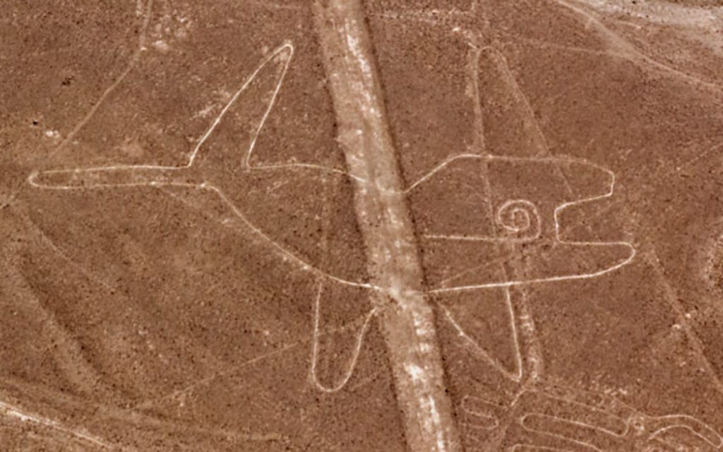
There are more than 140 forms that go from some already known, such as monkeys and snakes, to others that have surprised scientists, such as a humanoid being with a staff whose meaning will now begin to be studied.
Among the most striking and popular geoglyphs are the following:
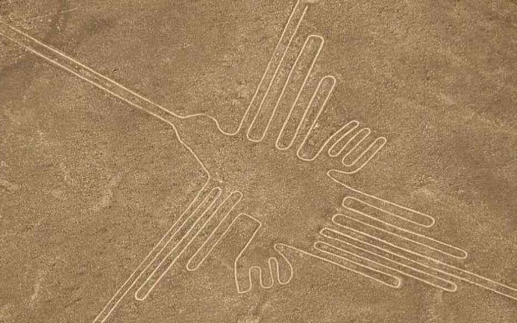
The hummingbird
It stands out for its harmonic dimensions. Between its two wings there is a distance of about 66 meters.
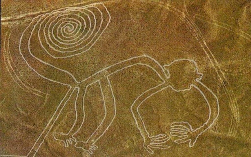
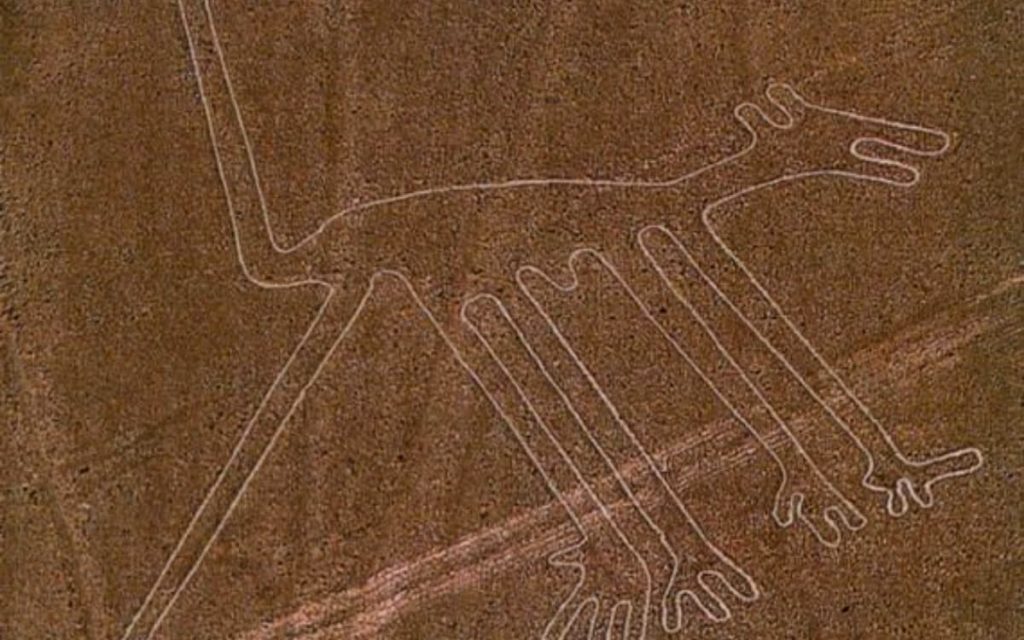
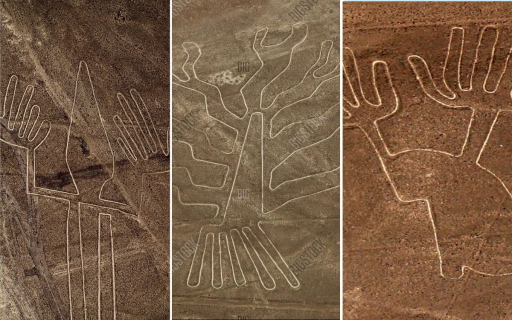
Monkey
It has a spiral-shaped tail and nine fingers, and its length is 135 meters. It was discovered by María Reiche, who considers that the tail and the hands of the geoglyph are directly related to the constellations and the rainy season. It is believed to represent the Big Dipper.
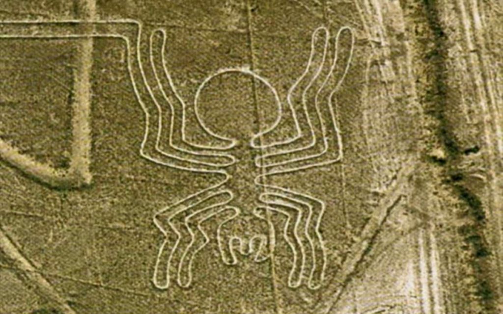
The spider.
It is another of the most characteristic figures of Nazca Lines in South América. It is about 46 meters long and is believed to have been designed to prevent droughts.
The giant bird.
It measures 300 meters long and 54 wide. It has a snake-shaped neck and its beak points directly towards the point where the sun rises in June. Researchers consider that it is the «Announcer of Inti Raymi», the solar festival of the Incas.
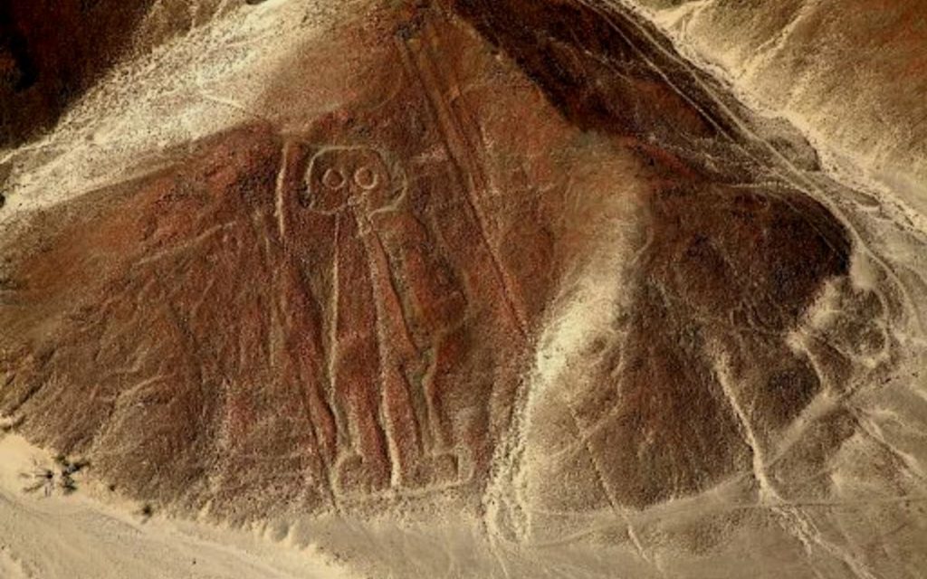
The astronaut.
It is a strange anthropomorphic figure that has become one of the best known of the Nazca Lines.
Pseudo-archaeological theories defend that it is a figure with a diving suit or helmet and rely on it to explain that the Nazca Lines geoglyphs were drawn as messages for aliens.
The whale.
It is about 60 meters wide and 20 meters high. Researchers believe it symbolizes a marine deity.
Trapezoids
This is one of the Largest Figures of the Nazca Lines in South América.
The dog
The dog is one of the leading figures of the Nazca Lines in South América.
The Condor
The Condor of the Nazca Lines is one of the widest that exists, because it has open wings.
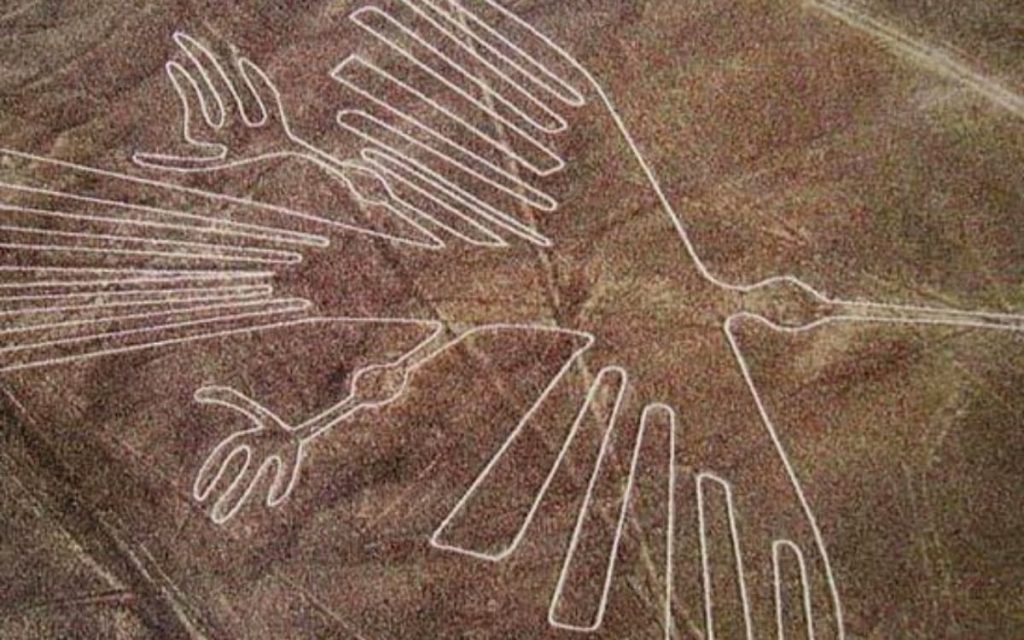
The Lizard, The Tree, The Hands
It is possible to observe these three figures together from the Nazca Lines Viewpoint.
History of Nazca Lines
According to the history of Nazca Lines, the first testimonies of the existence of the Nazca Lines date from the year 1547. The Spanish historian and chronicler Pedro Cieza de León explained that he had seen «signs in some parts of the Nazca desert.» However, these claims were not investigated at the time and were forgotten.
Although the shapes can be seen from the nearby hills, it was the Peruvian pilots who warned of their presence. In 1929 the Peruvian archaeologist Julio César Tello began to study them, and the same year Paul Kosok began his research. The North American anthropologist was studying the lines until the 1950s, and was in charge of finding out that they date from 550 AD using the Carbon-14 technique.
After the Second World War, a German-born teacher named Maria Reiche made the first formal studies of lines and figures, called geoglyphs. Reiche played a fundamental role in the conservation of the Nazca Lines geoglyphs. The ferocity with which this woman protected the lines from intruders has been adopted by her current guardians, making it difficult for even scientists to access the most famous animal figures carved in the pampas just northwest of Nazca.
In 1993, the geoglyphs became an archaeological reserve and part of the Cultural Heritage of the Nation of Peru.
A year later they were declared a World Heritage Site by the United Nations Educational, Scientific and Cultural Organization (Unesco).
«They are the most outstanding group of geoglyphs in the world and are incomparable in extension, magnitude, quantity, size and diversity with any other similar work in the world,» said UNESCO.
The Swiss Liechtenstein Foundation for Archaeological Research Abroad was the institution that carried out the first systematic field study. The research, led by archaeologists Markus Reindel and Johny Isla Cuadrado since 1996, has excavated and documented more than 650 sites to analyze the drawings and clarify their meaning.
In 2015, a team of researchers from the University of Yamagata (Japan) presented the results of their study, which demonstrated its origin and also its possible function. According to his theory, the Nazca Lines geoglyphs adorned the pilgrimage road to the pre-Inca city of Cahuachi, capital of the Nazca culture.
Recently, last April 2018, Peruvian archaeologists announced the discovery of 50 new geoglyphs, discovered thanks to the help of drones and satellite data. According to the impressions of these archaeologists, among whom is Luis Jaime Castillo Butters, some of the new lines discovered, which do not have a discernible pattern, were drawn by the Paracas and Topará cultures between 500 BC and 200 AD. , so that centuries before the inhabitants of the region were already experimenting with the drawing of figures on the ground of enormous dimensions.
Who made Nazca Lines?
American anthropologist Paul Kosok was one of the first researchers to hypothesize about the origin of the Nazca Lines. According to his theory, they were traced by the Nazca civilization, an archaeological culture of Ancient Perú, which developed in the valleys of the current department of Ica between 300 BC and 600 AD. In addition, the hypothesis is reinforced by the coincidence of the drawings of the roads with those that appear in the ceramics of the Nazca culture.
Therefore, the Nazca Lines are considered to have been made by the Nazca culture, which flourished in Peru in the 1st century BC. C., long before the Spanish conquerors arrived. They were built by piling up stones, and archaeologists believe that the drawings of animals represented their gods, and that the geometric figures marked the movement of the stars.
Who discovered Nazca Lines?
Nazca Lines are located in the Pampas de Jumana in the Ica region, and were discovered in 1927 by the archaeologist Toribio Mejía Xespe.
According to Paul Kosok, an American academic who dedicated himself to their study, they were «the largest astronomical book in the world», marking the winter and summer solstices; However, the most in-depth work began in 1946, when the German researcher María Reiche took charge of her, a task that she carried out until the end of her life.
María Reiche is remembered for having measured almost 50 figures with a tape measure, her main work tool, along with her ladder, compass, broom, notebook and her mathematical mind.
But now, a group of Japanese experts has found, through the use of state-of-the-art technology, a group of geoglyphs that they had no idea existed.
The Japanese team of experts, led by archaeologist Masato Sakai, who has found other lines before, initially conducted a field study between 2016 and 2018, which involved an analysis of the materials used and the terrain.
With the data obtained and after processing high-resolution images, they projected the figures and discovered 142 new shapes that include fish, llamas, monkeys and birds.
To facilitate their identification, the Japanese experts divided them into two groups:
Group A
- They are line drawings and tend to be larger: they measure more than 50 meters each.
- It is believed that they were the most recently created and their origin varies between 100 and 300 AD.
Group B
- They tend to be smaller and more complex structures: less than 50 m.
- They are believed to be older, built around 100 BC. C., or even before that date.
- According to the scientists, each group would have had different purposes: the first would have been used for rituals that involved the use of ceramics and the second for more decorative purposes.
Mystery of Nazca Lines
The aura of mystery that surrounds this pre-Inca work is due to three fundamental characteristics:
- its monumentality;
- the fact that the designs can be fully appreciated only from great heights;
- its location in the middle of one of the driest deserts in the world.
Theories about Nazca Lines
Some consider them simple ways of worship, others believe that they are a gigantic calendar, others that it is some kind of ritual to invoke the rains … Next, we summarize the main theories.
Peruvian archaeologist Julio César Tello, the first to study them, described them as a series of «sacred roads.» Later, in 1932, Toribio Mejía Xesspe pointed out that the lines were part of a disappeared cult and that they were nothing more than roads with a religious sense.
Paul Kosok’s performance was different. The American anthropologist defined them as a great astronomical book, «the largest-scale calendar in the world.»
Along the same lines, the conclusions of María Reiche Neumann indicate that the shapes are a gigantic solar and lunar calendar that Peruvian astronomers used to make forecasts about the harvest and the rains.
The Swiss journalist and writer Henri Stierlin affirmed in 1983 in his book entitled «Nazca. The solution of an archaeological enigma», that the lines functioned as looms (in Nazca fabrics with a size greater than 20 meters have been found) and the figures they had a protective character.
The German archaeologist Markus Reindel and the Peruvian Johny Isla put forward another theory. According to them, the Nazca Lines geoglyphs were drawn as part of a ritual invoking the rains, since the area lacked sufficient water resources and was punished with long periods of drought.
In 2015, researchers from Yamagata University in Japan determined that although they were initially built for worship purposes, later they were located on the Cahuachi road so that pilgrims could admire them.
The so-called «Nazca lines», in the middle of the desert in south-central Peru, continue to intrigue scientists and visitors hundreds of years after their creation.
Pseudo-archaeological theories and legends
In 1968, the Swiss writer Erich von Däniken published the book «Memories of the future», in which he explained that archaeological remains demonstrated the visits of aliens to ancient civilizations. According to his theory, the aliens were received by the inhabitants of Earth as gods from heaven, and they shared some technological knowledge with humans.
Scientists have rejected the theories in this book because various evidence supported by the author has been shown to be fraudulent, fabricated, or stated under illogical premises.
How to see Nazca Lines?
The best way to see the Nazca lines is from the air. Most tourists discover this wonder aboard a plane that flies over the Nazca Lines and, circling in the air, gives you a glimpse of the shapes. This is definitely one of the best guided tours of Perú.
From the air you can see a hummingbird, a spider, a monkey and a human figure greeting you on the ground, among many other drawings. Although you may have already seen them in photographs, seeing them live is an impressive experience, literally out of this world.
There are several daily flights, lasting approximately 75 minutes each, departing from Pisco airport.
It is advisable to make a Nazca Lines flight – tour reservation in advance, given its high demand, especially in high season.
People can also see part of the figures from the new lookout tower, a 20-meter-high metal infrastructure, which was inaugurated in February this year. So schedule your visit to this Ica destination for later. It will fascinate you!
Nazca Airport
The María Reiche Neuman Airport is located 2.5 km from the center of the city of Nazca, it does not have regular air traffic.
This airport is normally only used by aircraft companies that fly over the Nazca Lines and Palpa Lines and rented flights.
Passengers using the airport must pay a fee for the use of its facilities. If you book an all inclusive vacation packages to Perú, you can forget about this fee.
Overflights of the Nazca Lines and Palpa Lines
The best way to see the Nazca Lines and Palpa Lines in all their magnitude is by flying over these large extensions in a plane, equipped with panoramic windows and audio guides on board during the flight. The best vacation packages to Perú will always include a flight over the Nazca lines.
The flight over the lines has an average time of 30 to 45 minutes, from the city of Nazca and is subject to weather conditions and air traffic.
If you travel by bus on the Lima / Nazca or Cusco / Nazca night service, the arrivals to Nazca are early in the morning and you can make the overflight and continue your trip by bus to the next destination.
How to visit the Nazca Lines?
The traditional way to visit the Nazca Lines is by bus from the cities of Lima, Ica, Paracas, Cusco and Arequipa.
Distances to the city of Nazca:
- From Lima: 460 Km.
- From Paracas: 205 Km.
- From Ica: 150 Km
- From Arequipa: 566 Km.
- From Cusco: 662 Km.
How to get to Nazca Lines from Lima?
The traditional way to get to Nazca is by land in tourist buses from the cities of Lima, Arequipa or Cusco. There are also flights rented in light aircraft from the city of Lima, Ica and Paracas.
Bus Transportation to Nazca Lines from Lima
Nazca is located at kilometer 460 of the Panamericana Sur highway and is a highway connection center, from where the Nazca / Cusco highway and continuation of the Panamericana Sur highway to Tacna and the border with Chile, crossing Arequipa.
The traditional way to get to Nazca is by bus from the cities of Lima, Ica, Paracas, Cusco and Arequipa, cities with which it has regular interprovincial bus transportation service.
Bus trip Lima / Nazca / Cusco
For visitors who want to know Cusco and Nazca, it is recommended to make the trip by bus Lima / Nazca / Cusco and return to Lima by air, allowing you to win a day by avoiding returning to Lima if you make the trip Lima / Cusco / Lima and then Born. The shuttle bus service is usually an overnight trip, saving time and fees.
Airplane trip to Nazca Lines from Lima
Alternatively, on flights rented from Lima associated with the overflights of the Nazca Lines and Palpa Lines, the Nazca airport does not have regular air traffic. Most Perú Vacation Packages to Lima include a tour to Nazca Lines.
0 comentarios